District prepares for Hurricane Ian as path shifts east overnight

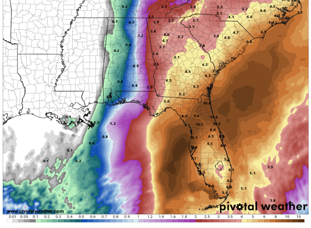
District urges residents to take precautions as the forecast is predicting heavy rainfall across the 18-county region.
District Emergency Operations Center Activated to Level 2
PALATKA, Fla., Sept. 26, 2022 — The St. Johns River Water Management District is closely monitoring Hurricane Ian and is taking proactive measures to help manage the anticipated rainfall in the coming days.

District urges residents to take precautions as the forecast is predicting heavy rainfall across the 18-county region.
Hurricane Ian shifted slightly east overnight, and while the forecast indicates Ian to be a category one hurricane when it reaches our region, residents should be prepared to experience high winds and significant rainfall.
The District is proactively preparing for the storm by taking the following actions:
- All District-managed navigational locks, campgrounds and properties, to include trails and day use areas, are closing Tuesday, Sept. 27, 2022, at 7 p.m. in anticipation of the storm until further notice. Please check the District’s website for the latest on land re-openings.
- The District’s Emergency Operations Center (EOC) has been activated to Level 2, which is a partial activation and means we are:
- Maintaining direct communications with the state and affected county EOCs; and
- Ensure current event information is distributed to all District staff.
- We are closely monitoring the storm’s path and water levels so we can provide information to the public and be prepared to assist our local government partners and other regional and state agencies as needed.
- In the Upper St. Johns River Basin and Upper Ocklawaha River Basin, the District manages a system of spillways, pump stations, levees, and canals. Using these structures, the District can adjust water levels for additional flood protection. Currently, the District is managing these control structures to maximize available storage for the storm event.
It’s important to keep in mind there are limits to what the District systems and lands can manage. The water control structures can reduce the amount of water flowing north from the Upper St. Johns River Basin. However, large tributaries, such as the Econlockhatchee River, can contribute more water to the middle St. Johns River than the amount flowing from the headwaters. Downriver of the upper basin, there are no comparable water control structures and flood protection is provided by the non-structural floodplain wetlands.
Additionally, tides and storm surge from the ocean influence the middle and lower St. Johns River. Water levels in the northern reaches of the St. Johns can rise with little advance notice.
Property owners should act now to be prepared for the storm’s heavy rains by:
- Keeping debris out of storm drains and ditches,
- Reporting clogged ditches to local governments,
- Cleaning out gutters and extending downspouts at least four feet from structures, and
Be sure to follow your county’s Emergency Operations Center for the latest local emergency updates. They serve as the primary entities responsible for emergency responses during storms including implementing state-of-emergency declarations, evacuations and rescue efforts during flood-related disasters. The District may assist local governments in their response and recovery efforts.
Visit the District’s website at www.sjrwmd.com/localgovernments/flooding/ for information and links to flood statements and warnings, river stages, and local government emergency contacts.

